“Agencies Announce the Frog Pond Wetlands Preserve Will Re-Open in 2026”
DATE: Friday, November 14, 2025
MONTEREY COUNTY – The Transportation Agency for Monterey County (TAMC) and the Monterey Peninsula Regional Park District (MPRPD) announced that re-opening of the Frog Pond Wetlands Preserve has been rescheduled to August 2026 while improvements are completed on the Canyon Del Rey segment of the Fort Ord Regional Trail and Greenway (FORTAG) project.
Both agencies had anticipated re-opening access to the Frog Pond next month, upon completing the first half of the undercrossing along State Route 218. However, unforeseen work associated with utility relocations and transmission pole support by PG&E shifted progress on construction later than anticipated. This was compounded by California Department of Fish and Wildlife and the Regional Water Quality Control Board restricting work in the Wetland Preserve during the winter season. As a result, work will need to stop by December 15th and not resume until April of next year. Leading up to the December deadline, the contractor, Graniterock, will winterize the area to protect the work zone and surrounding habitat. This stop in work pushes the completion of the work on State Route 218 and the re-opening of access to the Frog Pond to August 2026.
“While we know that this news is disappointing to those that wish to access the Frog Pond, this area continues to be an active construction zone. Our priority is keeping the public safe and it is unsafe to allow access to the Frog Pond area until construction is complete ” said Todd Muck, the Executive Director of TAMC.
Eric Morgan, General Manager of the MPRPD, added, “It is with great disappointment to see the FORTAG delays extend the Frog Pond Wetland Preserve closure well beyond our hopes—our visitors have been incredibly patient, and we feel that frustration deeply. The FORTAG project is a game-changer: it will deliver safer, ADA-compliant access, better connectivity across the region, and enhanced entrances that will connect more people to experience this incredible wetland. The wait is tough, but the upgraded access will be a lasting win for recreation and conservation.”
The Canyon Del Rey segment of the Fort Ord Regional Trail and Greenway (FORTAG) is the first phase of the larger 28-mile effort to connect communities in and around the former Fort Ord to each other and to educational institutions, employment, community, and open space.
It is anticipated that the completion of the Canyon Del Rey segment of the Fort Ord Regional Trail and Greenway will be completed in the Fall of 2026.
To learn more about the FORTAG project or to sign up for project updates, scan the QR code and click the project update page under the menu icon or visit https://www.tamcmonterey.org/fort-ord-regional-trail-greenway-canyon-del-rey.
For more information contact Theresa Wright, Outreach Coordinator, TAMC, at 831 775- 4411 or at theresa@tamcmonterey.org.
Background Information
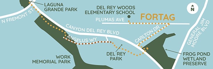
The Canyon Del Rey (CDR) Segment is the first phase of the overall FORTAG alignment. The segment runs from the intersection of North Fremont Boulevard and Canyon Del Rey/SR 218 (State Route 218) through Work Memorial Park and Del Rey Park, under SR- 218 into the corner of the Frog Pond, back up to SR-218 at Carlton Drive, then to Plumas Avenue where it will end at Del Rey Woods Elementary School. The trail will go under SR-218 with a new roadway bridge constructed to carry vehicles using the highway. Hikers, pedestrians, and bicycles will travel under the bridge through a 10.5-foot-high passageway.
FORTAG Canyon Del Rey Segment Project Map
###
###
The Transportation Agency for Monterey County (TAMC) is responsible for investing in regional transportation projects for Monterey County residents, businesses and visitors. The mission of TAMC is to develop and maintain a multimodal transportation system that enhances mobility, safety, access, environment quality and economic activities in Monterey County. For more information visit www.tamcmonterey.org or call 831.775.0903.
SPANISH LANGUAGE PRESS RELEASE
CONTACTO DE LANZAMIENTO: Theresa Wright
TELÉFONO: 831-775-4411E-CORREO: theresa@tamcmonterey.org
FECHA: Viernes, 14 de noviembre de 2025
"Agencias anuncian que la Reserva de Humedales del estanque de ranas reabrirá en 2026"
CONDADO DE MONTEREY – La Agencia de Transporte del Condado de Monterey (TAMC) y el Distrito de Parques Regionales de la Península de Monterey (MPRPD) anunciaron que la reapertura de la Reserva de humedales del estanque de ranas se ha reprogramado para agosto de 2026 mientras se completan las mejoras en el segmento Canyon Del Rey del proyecto Sendero y vía verde regional de Fort Ord (FORTAG).
Ambas agencias habían anticipado reabrir el acceso al estanque de ranas el próximo mes, al completar la primera mitad del cruce subterráneo a lo largo de la Ruta Estatal 218. Sin embargo, el trabajo imprevisto asociado con la reubicación de servicios públicos y el soporte de postes de transmisión por parte de PG&E cambió el progreso de la construcción más tarde de lo previsto. Esto se vio agravado por el Departamento de Pesca y Vida Silvestre de California y la Junta Regional de Control de Calidad del Agua que restringieron el trabajo en la Reserva de Humedales durante la temporada de invierno. Como resultado, el trabajo deberá detenerse antes del 15 de diciembre y no reanudarse hasta abril del próximo año. Antes de la fecha límite de diciembre, el contratista, GraniteRock, preparará el área para el invierno para proteger la zona de trabajo y el hábitat circundante. Esta parada en el trabajo retrasa la finalización del trabajo en la Ruta Estatal 218 y la reapertura del acceso al estanque de ranas hasta agosto de 2026.
"Si bien sabemos que esta noticia es decepcionante para aquellos que desean acceder al estanque de ranas, esta área sigue siendo una zona de construcción activa. Nuestra prioridad es mantener seguro al público y no es seguro permitir el acceso al área del estanque de ranas hasta que se complete la construcción", dijo Todd Muck, director ejecutivo de TAMC.
Eric Morgan, Gerente General del MPRPD, agregó: "Es con gran decepción ver que los retrasos de FORTAG extienden el cierre de la Reserva de humedales del estanque de ranas mucho más de nuestras esperanzas: nuestros visitantes han sido increíblemente pacientes y sentimos esa frustración profundamente. El proyecto FORTAG cambia las reglas del juego: brindará un acceso más seguro y compatible con la ADA, una mejor conectividad en toda la región y entradas mejoradas que conectarán a más personas para experimentar este increíble humedal. La espera es difícil, pero el acceso mejorado será una victoria duradera para la recreación y la conservación".
El segmento Canyon Del Rey del Sendero y vía verde regional de Fort Ord (FORTAG) es la primera fase del esfuerzo más grande de 28 millas para conectar a las comunidades dentro y alrededor del antiguo Fort Ord entre sí y con las instituciones educativas, el empleo, la comunidad y los espacios abiertos.
Se anticipa que la finalización del segmento Canyon Del Rey del Sendero y vía verde regional de Fort Ord se completará en el otoño de 2026.
Para obtener más información sobre el proyecto FORTAG o para registrarse para recibir actualizaciones del proyecto, escanee el código QR y haga clic en la página de actualización del proyecto debajo del icono de menú o visite https://www.tamcmonterey.org/fort-ord-regional-trail-greenway-canyon-del-rey.
Para obtener más información, comuníquese con Theresa Wright, Coordinadora de Divulgación, TAMC, al 831 775-4411 o al theresa@tamcmonterey.org.
Antecedentes
El segmento de Canyon Del Rey (CDR) es la primera fase de la alineación general de FORTAG. El segmento se extiende desde la intersección de North Fremont Boulevard y Canyon Del Rey/SR 218 (Ruta Estatal 218) a través de Work Memorial Park y Del Rey Park, bajo la SR-218 en la esquina del estanque de ranas, de regreso a la SR-218 en Carlton Drive, luego hasta Plumas Avenue donde terminará en la Escuela Primaria Del Rey Woods. El sendero pasará por debajo de la SR-218 con un nuevo puente de carretera construido para transportar vehículos que usan la carretera. Excursionistas, peatones y ciclistas viajarán bajo el puente a través de un pasaje de 10.5 pies de altura.
Mapa del proyecto del segmento FORTAG Canyon Del Rey
###
a Agencia de Transporte del Condado de Monterey (TAMC, por sus siglas en inglés) es responsable de invertir en proyectos de transporte regional para los residentes, empresas y visitantes del Condado de Monterey. La misión de TAMC es desarrollar y mantener un sistema de transporte multimodal que mejore la movilidad, la seguridad, el acceso, la calidad del medio ambiente y las actividades económicas en el condado de Monterey. Para obtener más información, visite www.tamcmonterey.org o llame al 831.775.0903.